- Press Release
- 2023/09/01
‘NERV Disaster Prevention’ App Launches Strong-Motion Monitor Layer Feature
Gehirn Inc. (Headquartered in Chiyoda-ku, Tokyo; CEO: Daiki Ishimori; hereinafter ‘Gehirn’) has released an update for the ‘NERV Disaster Prevention’ app on September 1st, 2023 (Disaster Prevention Day) with Strong-Motion Monitor Layer functionality in version v5.0.0.
The initiative was implemented on an experimental basis from February 2023 based on the "Joint Research Implementation Plan for the Utilisation of Strong-Motion Monitor Data" which was established by four parties: the National Research Institute for Earth Science and Disaster Resilience (hereinafter ‘NIED’), Gehirn Inc., TBS Television Inc., and TBS / JNN NEWS DIG LLC.
Gehirn Inc. processes and distributes the information received from a dedicated communications line installed at NIED. This dedicated line uses a redundant configuration to ensure a fast and reliable service for the NERV Disaster Prevention app. Please note that this is a separate service from the ‘Strong-Motion Monitor’ web service provided by NIED.
About the Strong-Motion Monitor Layer
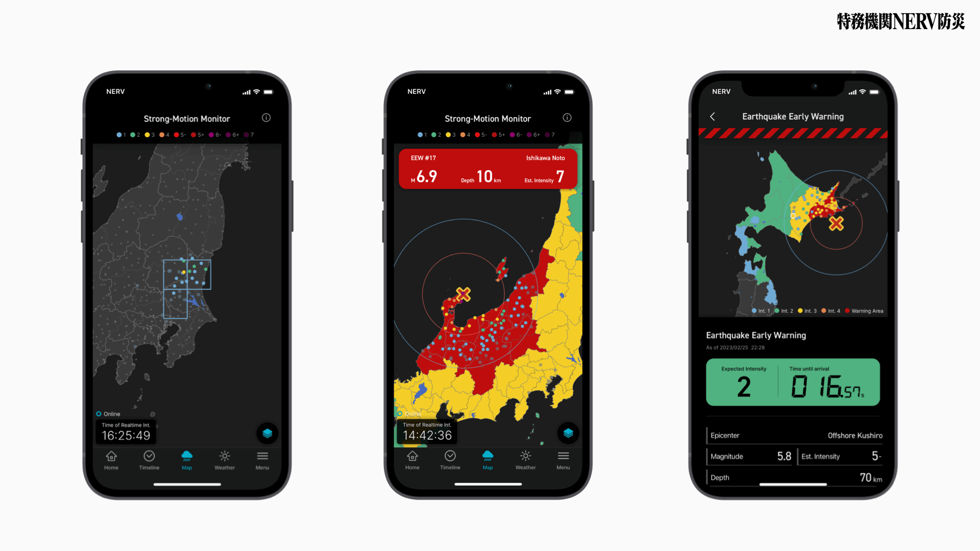
The Strong-Motion Monitor Layer is a feature that displays the real-time shaking situation throughout Japan, as observed by the Strong-Motion Observation Network (a network of seismometers for recording strong shaking), operated by NIED.
During an earthquake, the colour changes show the seismic wave propagation caused by the tremor. When changes occur at several observation stations, the screen automatically zooms to the affected area and highlights the stations based on a grid. When all of the grid squares are gone, the screen returns to show the whole country.
When an Earthquake Early Warning (Forecast) is issued, the Strong-Motion Monitor layer automatically integrates and displays the information from the EEW, including the forecasted Seismic Intensity distribution and estimated propagation of the P- and S-waves alongside the Strong-Motion data.
Precautions for Using the Strong-Motion Monitor Layer
- There is a delay of a few seconds from the actual shaking to its display on the Strong-Motion Monitor layer.
- The real-time seismic intensity displayed is not the seismic intensity information released by the Japan Meteorological Agency (hereinafter ‘JMA’), and may not correspond to the JMA seismic intensity even if the observation points are coloured on the Strong Motion Monitor layer or the Earthquake Early Warning screen.
- The ground shakes slightly on a daily basis due to everyday vibrations (cars, trains, factories, construction, etc.), so there may be a change in colour even under normal conditions. Also, as we process observation data in real time, changes in colour may occur due to noise or equipment malfunctions.
- The Strong-Motion Monitor layer is intended to provide an intuitive picture of the shaking of an earthquake by visualising the shaking at multiple points on a map. In addition, to enable users to also check information on the occurrence of an earthquake, the monitor can overlay the estimated epicenter information of the corresponding Earthquake Early Warning, the P-wave and S-wave propagation maps and the distribution of the expected seismic intensity.
- By enabling shaking detection notifications, users can receive push notifications when a change that is thought to be an earthquake is detected. In some cases, earthquakes for which no earthquake early warning has been issued can also be detected and notified. Please note that the detection method is not perfect, and notifications may be sent due to false positives.
- In some cases, the Strong-Motion Monitor layer may display multiple small round icons, so people with trypophobia should exercise caution when using this function. If you feel uneasy or uncomfortable, do not force the use of this function and consider disabling it.
- Although every effort is made to ensure continuity and stability of the transmission, the Strong-Motion Monitor layer may be temporarily unavailable due to system maintenance, line breaks with the National Research Institute for Earth Science and Disaster Prevention, or issues with data centre facilities or the transmission network. No responsibility is assumed for any damage caused by the use or unavailability of the strong-motion monitoring layer.
- Analysing the behaviour of APIs or apps that distribute Strong-Motion Monitor data, or accessing APIs that distribute Strong-Motion Monitor data from outside the Service in a manner not intended by Gehirn Inc., is prohibited according to Article 6-1 of the NERV Disaster Prevention Terms of Use'.
History and Development of Earthquake Observation in Japan
Japan is one of the world's most earthquake-prone countries, having experienced many significant earthquakes in the past. The Great Kantō Earthquake of September 1st, 1923, caused extensive damage to the Tokyo metropolitan area and surrounding regions, marking the deadliest calamity in Japanese history, with upwards of 105,000 people dead or missing. The date of this earthquake's occurrence, September 1st, has been designated as 'Disaster Prevention Day,' marking the beginning of modern Japan's disaster prevention and mitigation efforts.
The Great Hanshin-Awaji Earthquake of 1995 caused extensive damage in a wide area of the Kinki region, particularly in Kobe City and the Hanshin area. It was also the first earthquake in history to be recorded with a seismic intensity of 7. At the time, seismic intensity was determined by the physical sensations of JMA staff and on-site surveys. However, based on the opinion that this could cause delays in disaster prevention response, starting from October 1996, seismic intensity has been determined mechanically based on measured recordings.
The Great Hanshin-Awaji Earthquake led to the online centralised processing of data from seismic stations operated by various organisations. The strong-motion seismic observation network (K-NET, KiK-net), which has been operated by NIED since 1996, has approximately 1,700 strong-motion seismographs installed nationwide. The high-density seismic network (Hi-net), which records even faint tremors that humans cannot feel, and the broadband seismic network (F-net), which accurately records tremors of various periods, have also since been installed. Hi-net is used not only for research on earthquakes and earthquake disaster prevention, but also for the rapid announcement of seismic intensity and earthquake early warnings, making it indispensable today.
The Earthquake Early Warning system has been in operation since October 1st, 2007, providing prompt announcements of the expected maximum seismic intensity and arrival times immediately after an earthquake occurs. The Earthquake Early Warning System observes the initial microtremors (P-wave) of an earthquake and forecasts them before the main stronger tremor (S-wave) arrives, with the aim of providing valuable time to take emergency action before the tremors become stronger. Earthquake Early Warnings are widely communicated to the public via television, radio, mobile cellular alerts and apps. Since then, the Earthquake Early Warning system has been improved through the efforts of various researchers and engineers, and new indicators have been introduced one after another, such as methods to improve the accuracy of epicenter determination, methods to predict seismic intensity, and long-period ground motion.
In April 2023, the JMA's Working Group on “Utilisation of Earthquake Early Warning Evaluation and Improvement” discussed the further utilisation of earthquake early warning technology and indicated a direction for its future evolution. Based on this report, the JMA aims not only to advance early earthquake warning technology, but also to seamlessly integrate forecasting and observation.
As Gehirn was involved in the deliberations of this subcommittee, we are committed not only to making recommendations but also to advancing the social implementation of these findings. As part of this update, we have enabled real-time understanding of the changes and spread of tremors during an earthquake by utilising data from NIED’s Strong-Motion Monitor data. This allows us to seamlessly convey both early earthquake early warning forecasts and real-time seismic intensity (observation) through the app.
To Communicate “As Quickly As Possible”
At the time of the Great Kantō Earthquake, there was little information available to the public to use for disaster prevention. However, 100 years later, we are now able to provide users with a countdown to the expected seismic intensity and arrival time based on their location, as well as real-time seismic intensity updated every second.
We have been working for years to strengthen our information delivery infrastructure and to speed up our apps in order to deliver information as quickly as possible. We are very pleased to be able to provide new information "every second" with this update. However, the information delivery infrastructure and applications we have implemented are just the beginning of this technology. The provision of such advanced earthquake information is the result of a history of various legislations, administrations, and research and development, as well as the relentless efforts of our predecessors. Technical improvements will continue, and we, too, are committed to leaving a better disaster prevention information system for the next generation.
Gehirn will continue to strengthen our disaster prevention information distribution services further.
Overview of the ‘NERV Disaster Prevention App’
| Name | NERV Disaster Prevention App (Japanese: 特務機関NERV防災アプリ) |
|---|---|
| Official Website | https://nerv.app/en/ |
| Release Date | iOS: 2019/09/01 (Disaster Prevention Day) Android: 2019/12/18 |
| Price | Free |
| Supported OS' | iOS 13 (or newer) Android 6.0 (or newer) |
| Developer | Gehirn Inc.,
|
Access a Wide Range of Disaster Prevention Information in One App
The NERV Disaster Prevention app offers an extensive array of disaster prevention and weather information in just a single app. Receive alerts for real-time earthquake early warnings that show the estimated seismic intensity, propagation of P and S waves, and time until the arrival of shaking at your location. Get notified for earthquake, tsunami, and volcanic eruption bulletins, weather warnings, heavy rain risk, flooding/inundation risk, landslide hazards, and even Civil Protection Information (J-ALERT). View typhoon forecasts, rain cloud radar, river level information and more by manipulating the map on the screen. Zoom in on any location to see information in greater detail or pan across the country to see the rain cloud cover and lightning hotspots of neighbouring cities. You can even view the measured seismic intensity of earthquakes at any scale.
1. Providing Users With the Most Appropriate Disaster Information
Information is displayed based on your current location and pre-registered areas, depending on the priority level assigned to each type of information. We use our own subdivision and mesh data to provide you with the most appropriate information.
2. Push Notifications for Important Information
Critical Alerts, Normal Notifications or Silent Notifications will be issued depending on the user’s location, the type of disaster information, and the level of urgency. If there is an imminent danger and the user must act quickly, like in the case of an Earthquake Early Warning or Tsunami Warning, Critical Alerts get the user’s attention by breaking through the phone’s Silent/Do Not Disturb/Focus modes and sounding at maximum volume.
※ If you do not wish to receive Critical Alerts, you can disable them from the Settings screen. If Critical Alerts are disabled, you will instead receive these notifications as Normal Notifications.
3. Barrier-Free Design
When we began developing the NERV Disaster Prevention app, we implemented various aspects of accessibility from the very beginning and have further improved upon these features over time. As it currently stands, inclusive colour schemes, screen-reader compatibility, contrast adjustment, font thickness and text size are all customisable by the user in order to ensure that information remains accessible to all.
■ Corporate Overview
URL: https://www.gehirn.co.jp/
Est. 2010/07, Gehirn is an IT and Security company that provides 'Gehirn Web Services' (an infrastructure service), Corporate Vulnerability Analysis, and Disaster Preparedness and Weather Information distribution services, all focused around our mission to 'Make Japan Safer'.
■ For other inquiries, please contact us
Gehirn Inc. (ゲヒルン株式会社)
Contact Form: https://www.gehirn.co.jp/en/contact/