- Press Release
- 2021/05/13
Visualize Disasters in Real-Time with Gehirn's Disaster Prevention Information through the power of ArcGIS
In partnership with ESRI, Gehirn announces the launch of a service to visualize and analyze real-time disaster prevention and weather information provided by Gehirn on ArcGIS.
ESRI Japan (Headquartered in Chiyoda-ku, Tokyo, President: Chiharu Masaki), Japan’s largest provider of GIS (Geographic Information System) software*1, and Gehirn Inc. (Headquartered in Chiyoda-ku, Tokyo; CEO: Daiki Ishimori; hereinafter referred to as 'Gehirn'), a provider of the “NERV Disaster Prevention” mobile application, have announced the launch of “ESRI Japan Data Contents Online Suite Weather Online Service (Gehirn Edition)”, hereinafter referred to as the “Online Weather Service” – has been launched as a new service that distributes real-time disaster prevention weather information, such as landslide, inundation and flood risks, and emergency weather warnings provided by Gehirn on ESRI Japan’s location intelligence platform “ArcGIS”.
Background
Until now, disaster-related information had to be collected independently from a variety of sources, including national and local governments, each with different communication protocols and data formats. In addition, companies had to integrate the collected data with their own data, keep up-to-date and accurate on new developments, and build and maintain systems to use the information.
In response to this situation, ESRI Japan and Gehirn have launched a service to support companies’ rapid disaster prevention activities by linking Gehirn’s best-in-class real-time disaster prevention and weather information services with ArcGIS. By overlaying your company’s data with Gehirn’s disaster weather information, you can instantly identify the locations and number of people affected.
Services
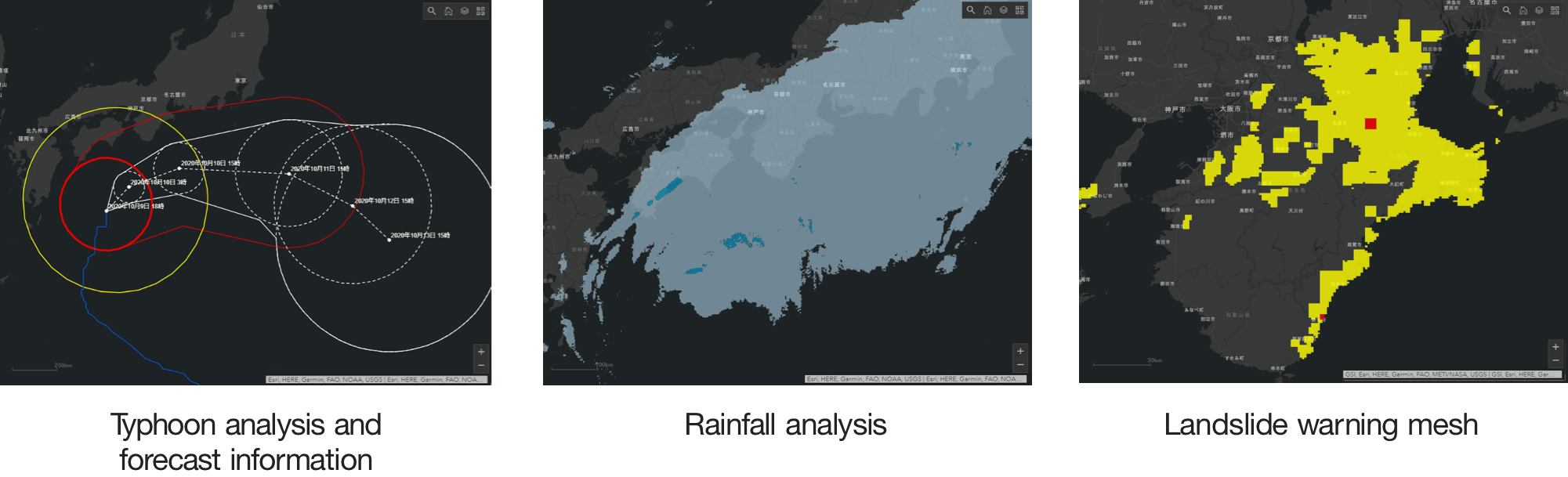
Gehirn’s real-time disaster prevention and weather information, which includes landslide, inundation and flood risk, analytical rainfall, and emergency weather warnings, is now available as a paid optional service on the ArcGIS platform. The service can be used with any ArcGIS product with an internet connection, and can be combined with your own data to help your company make quick decisions. The service provides the following disaster prevention weather information:
- Landslide risk level (landslide warning information, landslide warning mesh information)
- Flood risk (heavy rainfall warning for flooding risk distribution)
- Flood damage risk (flood warning risk distribution, designated river flood forecast)
- Weather Warnings and Advisories (Severe Weather Warnings/Warnings/Advisories and possibility of warning data)
- Typhoon analysis and forecast information
- Rainfall analysis
We will continue to add more disaster weather information as it becomes available, so that we can respond to all possible disaster risks.
Examples of weather information for disaster prevention
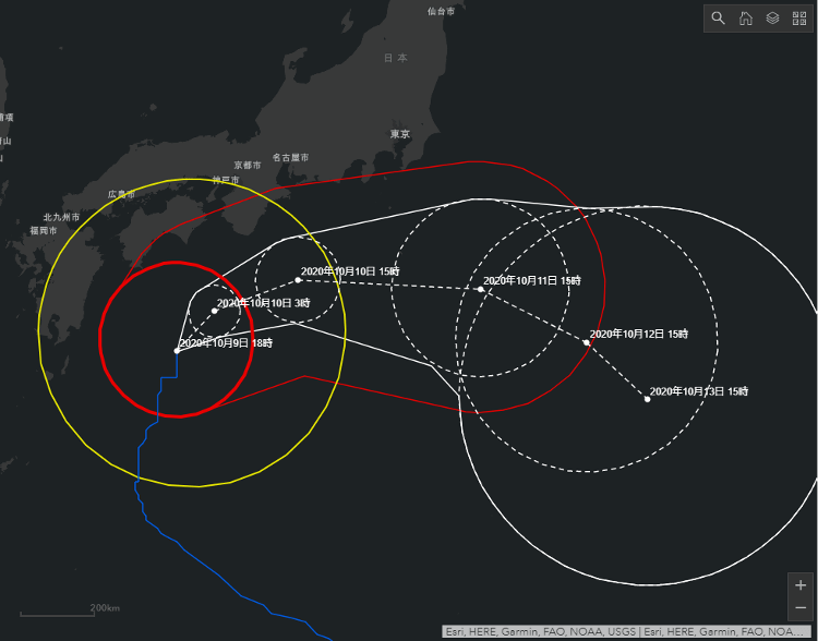
Typhoon analysis and forecast information
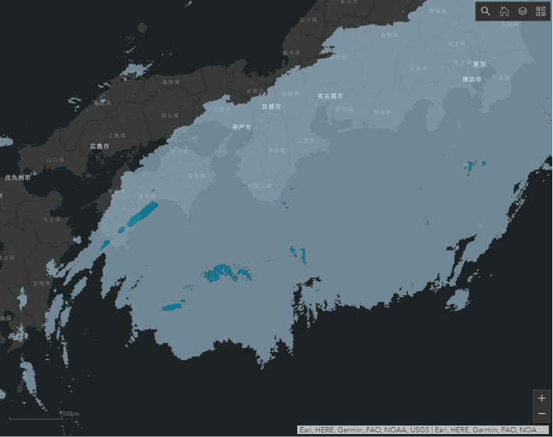
Rainfall analysis
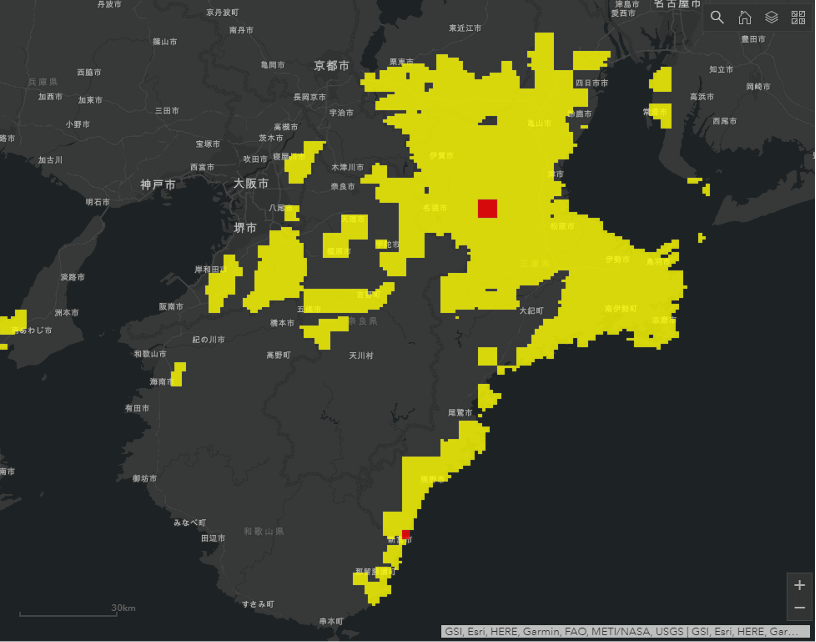
Landslide warning mesh
More information about the Online Weather Service: https://onlinesuite-gehirn-ej.hub.arcgis.com/ (Japanese only)
Usage Examples
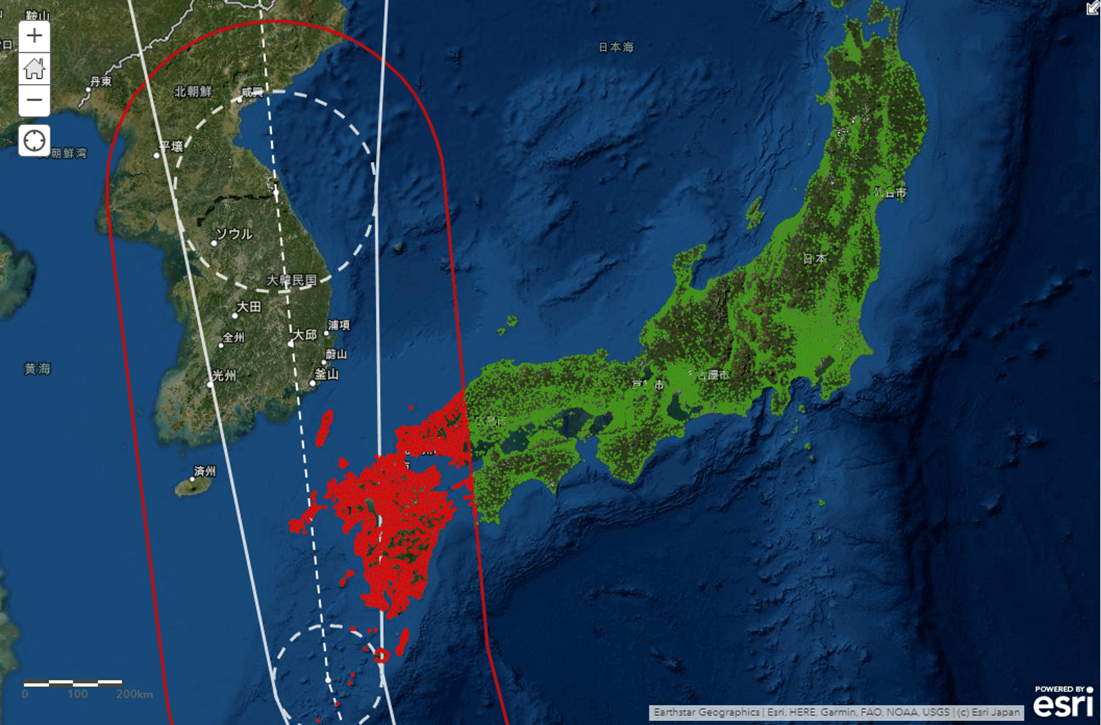
Figure 1: Extraction of insured people in the path of a typhoon
The “Online Weather Service” can be used in ArcGIS to perform a variety of analyses. For example, an insurance company can plot its insurance subscribers on a map and overlay disaster weather information to identify customers in areas where disaster risk is expected to be high. The system can be used to minimize damage by calling for disaster prevention actions and to estimate damage in advance in order to prepare for insurance claims. (Figure 1)
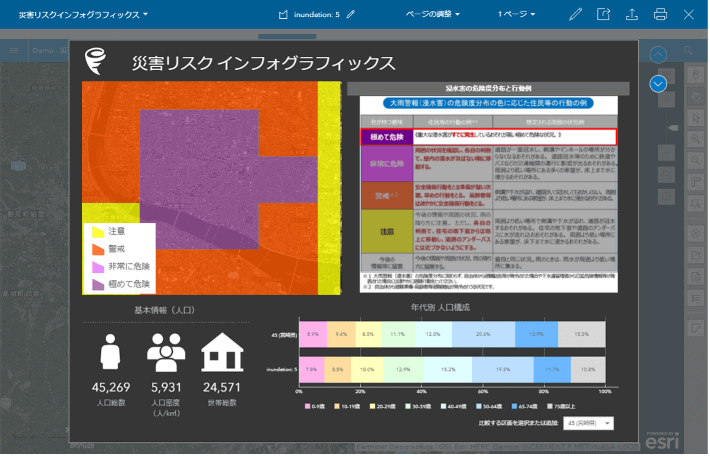
Figure 2: Screenshot of aggregated demographics of high risk areas
ArcGIS also contains demographic data such as census data, which can be used to count the population and households in any area. By combining this function with disaster prevention meteorological information and compiling the aggregate results into a report format, it is possible to quickly grasp the population and number of households and their age structure in areas where various disaster risks are increasing. This will help local governments, for example, to set up appropriate shelters according to the type of disaster risk and the size and characteristics of the population. (Figure 2)
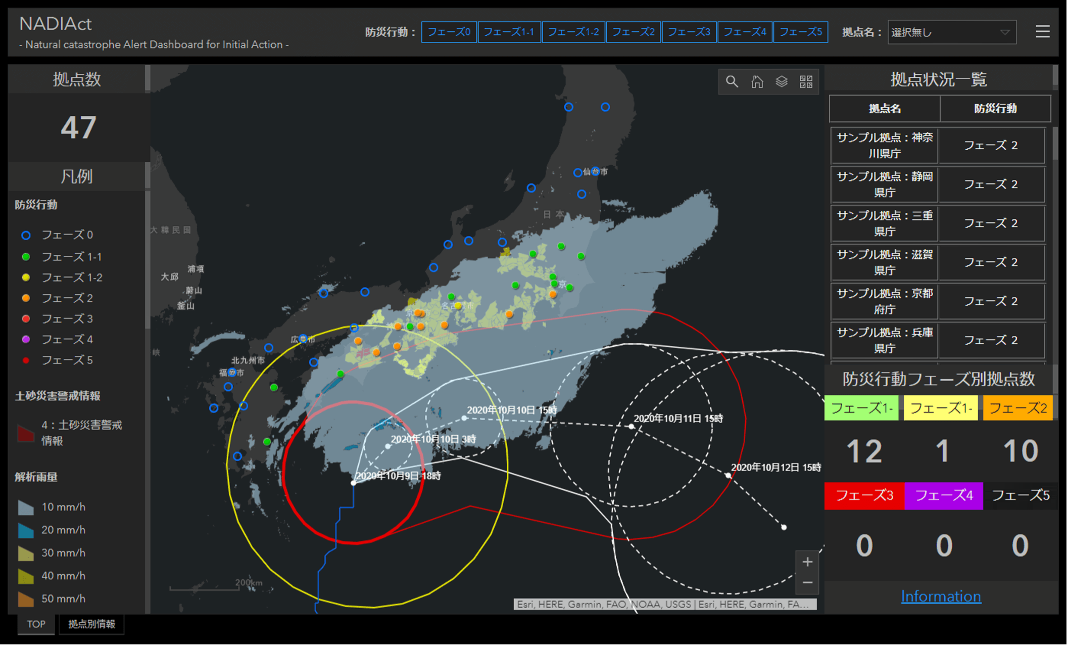
Figure 3: NADIAct screen image
Additionally, by integrating information such as the locations of your company’s stores and factories, combined with the power of ArcGIS, you can predict and notify where and what kind of danger exists at any location, so you’re able to enhance your company’s disaster response and mitigation efforts to protect your company’s supply chain. With this service serving as a source of basic disaster risk information, NADIAct (Natural catastrophe Alert Dashboard for Initial Action), a cloud GIS service for disaster prevention and mitigation which was launched on October 2020, allows users to receive alerts when disaster risk increases in their surroundings by simply registering their location information while having a bird's eye view of disaster risk information. (Figure 3)
More information about NADIAct here: https://nadiact-hub-ej.hub.arcgis.com/ (Japanese only)
Company Overview
ESRI Japan
| Head Office | Shiozaki Building, 2-7-1 Hirakawacho, Chiyoda-ku, Tokyo 102-0093 |
|---|---|
| Representative | Chiharu Masaki, President and Representative Director |
| Established | 2002/04/01 |
| Business Description | Sales of GIS software and provision of related services (support, training, consulting services) |
| URL | https://www.esrij.com/ |
Gehirn Inc.
| Head Office | Seki BLDG. 7F, 1-3-6 Kudankita, Chiyoda-ku, Tokyo 102-0073 |
|---|---|
| Representative | Daiki Ishimori, President |
| Established | 2010/07/06 |
| Business Description | Security consulting and advisory vulnerability assessment; planning, management, operation, and sale of rental server services; analysis and information distribution of disaster prevention and weather information |
| URL | https://www.gehirn.co.jp/en/ |
For inquiries regarding this matter, please contact (Japanese)
*1 According to the Yano Research InstituteESRI Japan
Sales Promotion and Marketing, ESRI Japan - Fujisawa
Phone: 03-3222-3941 / Email: gisinfo@esrij.com
■ Corporate Overview
URL: https://www.gehirn.co.jp/
Est. 2010/07, Gehirn is an IT and Security company that provides 'Gehirn Web Services' (an infrastructure service), Corporate Vulnerability Analysis, and Disaster Preparedness and Weather Information distribution services, all focused around our mission to 'Make Japan Safer'.
■ For other inquiries, please contact us
Gehirn Inc. (ゲヒルン株式会社)
Contact Form: https://www.gehirn.co.jp/en/contact/